Storm Chase Details
Miles Logged: 1247
States Chased: MN, WI
Largest Hail Encountered: 1.25 in.
Milestones: Second worst bust of career
Severe Risks: SPC Outlooks
Severe Reports: Storm Reports
June 17, 2010 is, and will hopefully remain my worst bust of my chasing career. A number of things went wrong which contributed to a painful day that I’d like to forget.
Departing Lansing
After working a full day of work, I left Lansing to head down to Battle Creek. I’d pick up L.B. and his dad and head out to what looked to be a very good setup. A 992mb low was ejecting into South Dakota with a trailing cold front and dryline. Deep tropical moisture was surging northward, with dewpoints of almost 70º in Minnesota on the afternoon of the 17th. There were concerns of capping, but it otherwise looked like a robust tornadic supercell setup.
We departed Battle Creek around 8 and began our journey to Minnesota. We made it to Tomah, WI where I90 and I94 split. Staying in Tomah would leave both the north and south targets available. Unfortunately, I attempted to find available rooms and came up empty. Everything in Tomah was sold out, so we continued onto Black River Falls.
Morning of the 17th
Waking up at the hotel in Black River Falls, we grabbed breakfast and hit the road. Indecision would hurt, with me choosing to head the 45 minutes back south to I-90 and then west on 90. SPC had put out a 10% hatched tornado risk across central and western Minnesota.
By early afternoon, we were in Alberta Lea and heading west. I could see the windshift/dryline in the surface observations, so I made the decision to stop in Jackson MN for lunch. Luverne was showing a southwest wind at that point.
Decision to go North
The decision was made to head north while we were eating lunch in Jackson. We headed north on US71. During our journey northward, I could see a storm firing near Clear Lake, South Dakota. The storm had a good radar presentation early on and I assumed that would be the storm to be on. It would be the storm to be on, but we’d never reach it in time.
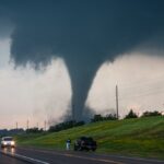
I went through Willmar and continued north towards I-94. Reports of tornadoes started pouring in from that storm as it crossed I-94. We were about 30 miles out as it started producing the monster tornado in Wadena.
Arriving on the Wadena Storm
As we neared the Wadena storm, we could see it was an HP beast. Driving through Wadena, it was obvious that a large tornado had just come through town. Trees were all over the road and road construction signs were thrown about. The damage we were looking at was EF1-EF2 tops. I had no idea at the time how intense the tornado was.
We’d follow the storm for a few hours afterwards, into the Duluth NWS County Warning area. With the tall trees and winding roads, I decided right then and there I’d never chase in the Duluth CWA ever again.
Ending the Chase
We ended up in Pine River, Minnesota before we gave up on that storm. It had been reduced to mostly a rain shower at that point, but was still Tornado warned. We dropped south towards Brainard, and got suckered into some more tornado warned storms (Radar coverage sucks up there – Between Grand Forks, Minneapolis/St. Paul and Duluth Radars) but saw nothing.
Eventually we said screw it, and went to Old Chicago in St. Cloud where I kept reading about everyones great fortune on my phone. Pictures and video were streaming out of the Wadena storm and the Albert Lea storms. We were empty handed.
Heading Home
We ended up driving to Menomonie, WI where we stayed the night. I had The Weather Channel on both that night and the next morning, and was treated to tons of video from Minnesota the previous day. Torture.
We later found out June 17, 2010 was the new record day for tornadoes in Minnesota and all we managed to witnessed quarter size hail. A major let down. The mood still hadn’t changed much the next day as we ate breakfast at the Taco Johns before hitting the road to chase Northern Illinois.
